Leveraging A Geographic Information System (GIS) in Public Audit

By: Senior Auditor – Mai Malek Abdin, SAI Egypt
Introduction
Emerging technology has revolutionized the world, and has become a preferred ally for auditors, as its use can significantly help in improving the efficiency and effectiveness of their work. Governments and public sector organizations worldwide are embracing innovative technologies to modernize their auditing practices. These technologies include blockchain, artificial intelligence (AI), data analytics, etc.
Among these technologies, Geographic Information System (GIS) plays a vital role. GIS provides auditors with a spatial perspective, which allow them to visualize and analyze data within a geospatial context. By using GIS, auditors can identify concentrated fraud risks in specific areas, evaluate the impact of geographic factors on audit outcomes and make well-informed decisions to enhance transparency and accountability in the public sector.
GIS is a “computer-based system for collecting, storing, analyzing, retrieval and display of spatial data” and this system is distinguished from other spatial systems by its large storage capacity.
By leveraging GIS, auditors can delve deeper into data analysis, uncovering patterns and spatial relationships that may not be readily apparent. This spatial understanding equips them with the ability to identify concentrated fraud risks in specific geographical areas and evaluate the impact of geographic factors on audit outcomes.
By making informed and data-driven decisions through GIS, auditors can enhance the accuracy and effectiveness of public sector auditing, and ultimately contribute to increasing transparency, improving resource allocation and strengthening accountability in the management of public resources.
Application of GIS in SAI Egypt: Case Study Audit
Egypt has faced considerable loss of agricultural lands over the past decade which led to heavy financial burdens for the State to compensate for the lost lands. This has been coincided with unauthorized construction, which caused the loss of a large space of agricultural lands and placed a strain on the state’s resources and infrastructure.
To tackle these challenges, Egypt initiated the “Go Green” initiative in January 2020 as one of State’s efforts to increase environmental awareness and encourage sustainable resource utilization. The initiative aims to achieve long-term sustainability and meet sustainable development goals within three years.
Egypt has also approved its commitment to combating global climate change through hosting the United Nations Climate Change Conference (COP 27) in 2022. As a part of strategic audit plan, SAI Egypt has considered the topics of environmental auditing and the implementation of sustainable development goals as a top priority.
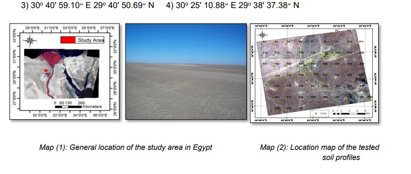
One of the recent audits conducted by SAI Egypt using GIS was “Assessing Performance and Impacts of Agricultural Land Fertility Programs through GIS Analysis”. The audit’s objective was to evaluate the effectiveness of these programs within an area of 50459.04 hectares along El Bahria Oasis road in Giza governorate. The specific focus was to assess the outcomes and impacts of the programs based on predefined criteria such as crop yield, improvement of soil quality, and sustainability.
The GIS was used in this audit in the following ways:
During the planning phase, auditors considered GIS methodologies to help them to select the audit topic and align it with SAI Egypt’s strategic audit plan. To further develop and improve the audit objectives, the auditors identified specific criteria and metrics to evaluate the effectiveness of the land fertility programs. The audit aimed to determine the extent to which these programs contributed to increasing agricultural productivity, improving soil characteristics, and enhancing sustainability in the targeted area. SAI Egypt selected this project, as agriculture projects were classified as priority projects at the national level.
In the data collection and analysis conducting phase, auditors – with the help of GIS experts – obtained and analyzed geographic information to verify the validity of audit evidence by comparing them with relevant standards.
Auditors conducted a risk analysis, considering factors like water sources and steep slopes within a geographical context. This helped to identify challenges and areas for improvement in land fertility programs.
The auditing team evaluated the area’s fertilizer requirements using a geographical database, ArcGIS capabilities, and created maps of fertilizer requirement based on the prevalent soil properties and expected usage of lands.
During the audit process, auditors used GIS to generate information on current and potential land capability, in addition to crop suitability.
In the reporting and follow-up phase, auditors leveraged GIS information to effectively communicate the audit results to stakeholders. The visualization capabilities of GIS enabled auditors to present a clear and concise message, using maps and visual representations in addition to written reports. This comprehensive approach allowed for greater understanding and transparency among stakeholders.
Audit Findings
Soil Nutrient Analysis: The audit findings indicate that the soil nutrient analysis, which was conducted as a part of the land fertility programs, was generally accurate and reliable. The GIS-based methodology effectively captured soil characteristics, nutrient status and land capability for crop cultivation. However, in some instances, auditors found variations in sampling methods and data inconsistencies, which require further attention and standardization.
Digital Mapping: The digital maps used, which were generated through GIS, depict soil characteristics and nutrient status, and were highly beneficial for assessing the land fertility programs. These digital maps, provided a valuable visual representation of the agricultural landscape. However, the auditors identified some minor discrepancies in certain areas, such as misrepresentations of soil types and limited resolution in specific zones, highlighting the need for ongoing improvements and updates.
Fertilizer Recommendations: The audit findings indicate that the fertilizer recommendations derived from the GIS analysis were generally aligned with the needs and requirements of the targeted area. This accuracy in fertilizer recommendations had a positive impacted on agricultural productivity and resource management. However, there were some cases where improper application methods or inadequate follow-up assessments applied led to suboptimal utilization of fertilizers, warranting improvements in implementation practices.
Audit challenges using GIS
In the context of the Agricultural Land Fertility Programs case study, there are several challenges associated with the use of GIS technology in the audit.
One primary challenge is the availability of accurate and up-to-date GIS data specific to the audited region. Since the evaluation of land fertility programs heavily relies on the analysis of GIS data, including remote sensing data and spatial datasets, and obtaining a high-quality data that reflects the current state of the audited region, is crucial. Inadequate data coverage, outdated datasets, or inconsistencies in data quality could affect the precision and reliability of audit findings.
Collaborating closely with relevant local agencies, agricultural research institutions, or other data providers is essential to ensuring access to reliable and current GIS data that aligns with the specific needs of the audit.
Additionally, interpreting and analyzing GIS data in the context of the case study poses some challenges. Because of the complexity of GIS analysis techniques such as spatial analysis, interpolation, and modeling, auditors should possess a deep understanding of GIS principles and methodologies.
In the case of evaluating land fertility programs, auditors must grasp the specific factors and variables, which affect soil health and nutrient management. The ability to assess spatial patterns and identify trends in the collected GIS data is crucial for deriving meaningful insights and conclusions. Clear, concise, and accurate communication of the GIS-based audit findings are equally important to both technical and non-technical stakeholders for effective decision-making and program improvement. Overcoming these challenges requires a combination of technical expertise, collaboration with local experts, and effective communication to ensure the successful integration of GIS analysis in the audit process.
Audit Recommendations
Integration of Advanced Technological Solutions: To enhance the accuracy and efficiency of soil nutrient analysis, it is advised that Egypt explore the incorporation of advanced remote sensing data and modeling techniques into GIS analysis of land fertility programs.
Lessons learned: It is important to prioritize standardized sampling methods and maintain consistent data quality for reliable and credible results.
Strengthening Capacity through Training and Skill Development: Investing in auditors training is crucial for effective land fertility program evaluation.
Lesson learned: Enhancing competence in GIS analysis, data collection, and interpretation is essential. Providing auditors with these skills improves audit accuracy and reliability, facilitating informed decision-making and successful program implementation.
Improvement of Implementation Practices: Enhancing implementation practices is pivotal to maximizing the benefits derived from fertilizer recommendations. The efficient and effective use of fertilizers can lead to increasing agricultural productivity and improving resource management.
Lesson learned: Vigilant monitoring of the implementation process helps identify and promptly address any discrepancies or gaps. This includes emphasizing proper application methods and regularly conducting follow-up assessments.
Strengthening the Monitoring and Evaluation Framework: Integrating GIS into the Monitoring and Evaluation (M&E) framework of audit can significantly enhance the effectiveness and efficiency of audit processes, leading to more informed decision-making and improved audit outcomes.
Lesson learned: A robust monitoring and evaluation framework is essential, using clear indicators to assess effectiveness and sustainability. Regular activities enable stakeholders to track progress, identify improvement areas, and make informed decisions.
Conclusion
By incorporating GIS into audits, supreme audit institutions can leverage geo-spatial methodologies to develop findings and recommendations based on spatial relationships, patterns, and messages. SAI Egypt effectively utilized GIS to assess Egypt’s agricultural land fertility programs and understand the programs’ outcomes and impacts. Despite the challenges of employing GIS analysis, GIS is still a valuable tool to incorporate into audits to solve complex spatial related problems, and understand and assess data from a geographic perspective.