Using GIS to Monitor Public Works

by the Federal Court of Accounts of Brazil (André Delgado de Souza, Juliana Santa Cruz de Souza, João Germano Lima Rocha) in partnership with researchers from the Federal University of Pernambuco (Maria do Carmo Sobral and Ana Lúcia Bezerra Candeias)
This paper presents an alternative model for auditing public works through intensive use of Information Technology (IT). The model is based on the use of Geographic Information Systems (GIS) for collecting, processing and analyzing data; producing tables, graphs and thematic maps; allowing remote monitoring of a large number of constructions; and providing a quick overview of the audited area.
To develop the model, literature reviews, interviews with experts, technical meetings, workshops, on-site inspections and experimental research were conducted. A case study with sewage public works was performed with experimental applications in 399 municipalities of the Brazilian Northeast, involving 142 contracts, totaling $300 million (Federal Court of Accounts of Brazil (TCU), 2015).
GIS in Government Audits
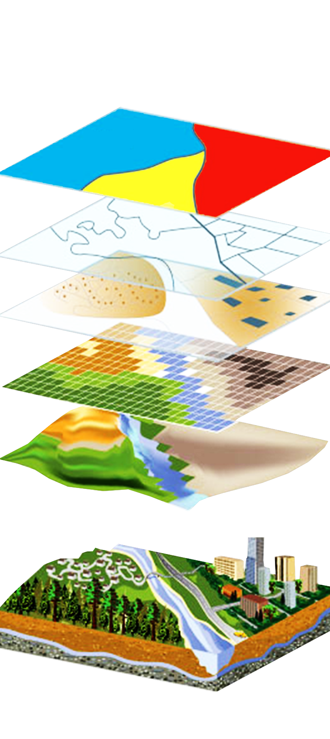
Geospatial information pertains to a specific location, associating each entity or phenomenon to an exact location on Earth. These computer tools allow you to store, integrate, maintain, visualize and analyze data from various sources and create geo-referenced databases and thematic maps (in which a great deal of information can be overlaid and interpreted). Figure 1 illustrates a schematic view of GIS layers.
GIS can play an important role in every stage of an audit, including selecting research areas and communicating audit results. Rentenaar and Williams-Bridgers (2006), Jongsma and Graaf (2008) and Musa (2012) presented practical GIS applications in audits connected to disaster-related aid, money laundering and the environment. These authors highlighted the important contributions of GIS for more effective control, especially by performing complex analyses through linking data layers and overlaying different datasets.
The International Organization of Supreme Audit Institutions (INTOSAI) published International Standards of Supreme Audit Institutions (ISSAI) 5540, concerning the use of geospatial information in auditing disaster management and disaster-related aid. The purpose of ISSAI 5540, to explain the benefits of using geospatial information in audit works, introduces GIS as an audit tool and encourages auditors to improve the use of geospatial information in their work (INTOSAI, 2013).
When analyzing the Brazilian Courts of Accounts, it was observed that roughly 50% of the courts systematically use, or are preparing to use, GIS in auditing public works. This information considered 28 Brazilian courts, 27 state courts and the federal court.
GIS for Remote Monitoring of Public Works
Developing methods to use government databases is featured due to the increasingly available amount of data. TCU has been intensively working to use IT resources, particularly public administration databases. The use of IT enables obtaining information about audited objects in a remote fashion to include highlighting audit findings through automated tests.
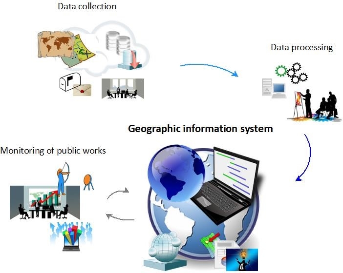
These systems are important in monitoring public works, as they allow for data treatment, integration and spatial analysis. Figure 2 shows a scheme of the developed model, which can be divided into four steps:
- Data collection: to collect data mainly from public information systems;
- Data processing: to standardize data, correct errors and integrate databases;
- Use of GIS: to organize information in a unique database and produce tables, graphs and maps;
- Monitoring of public works: GIS enables obtaining information about a large number of constructions, allows virtual monitoring, with a quick overview of the research area.
Thematic maps are an option to support decision-making processes related to the external control of public works. They enable (1) detection of areas with higher or lower occurrence of certain phenomena, (2) geographic pattern identification, and (3) predictive and correlation analyses.
Auditing Sewage Public Works
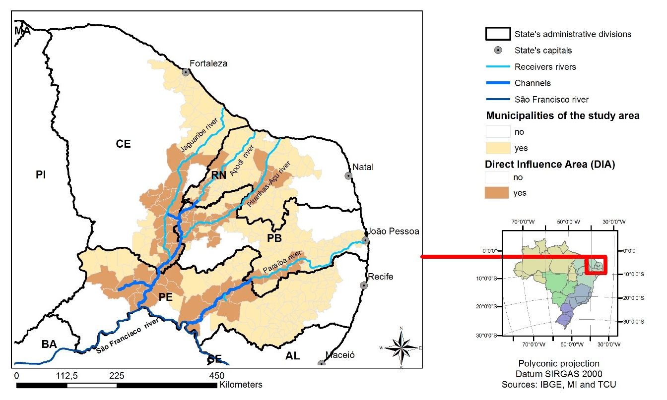
Between May 2014 and March 2015, TCU audited an area of 399 municipalities in the Brazilian Northeast, involving 142 contracts, totaling $300 million. The goal was to improve public works sewage governance in the region through the diagnosis and analysis of conditions associated with sewage construction, as well as identifying problems and bottlenecks related to projects never reaching conclusion (TCU, 2015).
The municipalities selected were those that would greatly benefit from Brazilian Federal Government projects. One such example is the São Francisco River Integration Project (PISF), involving the construction of two main channels for river basin incorporation.
Sewage infrastructure construction was among the predicted measures to maximize PISF benefits, a measure especially important for municipalities within the project’s Direct Influence Area (DIA), as raw sewage discharges could potentially damage water quality.
Figure 3 depicts the study area.
The main audit findings were:
- 55% of sewage construction was halted, in very slow construction rhythm or had not been initiated.
- 39% of sewage construction was not concluded, yet the contracts had already expired,
- 30% had expired environmental licenses.
- 13% of the hired construction companies did not possess operational capabilities to execute the public works.
- 9% of the contracts had atypical financial transactions in bank accounts.
There was also a risk of water pollution that existed from potential raw sewage discharges.
Regarding the project schedules in particular, “Figure 4: Sewage Public Works,” details realization conditions. The high percentage of unfinished and halted projects must be emphasized.
While there were many projects behind schedule and difficulties associated with project completion, there were also several undesired cases where new contracts were signed even prior to the conclusion of previous projects in the same municipality. The map in Figure 5 illustrates municipalities with three or more contracts for sewage constructions. In all of these municipalities, there were unfinished projects (some of them not even initiated and more than two years behind schedule). Additionally, there were projects that expected to be operational nearly 10 years prior, but as of the date of this study, were still under construction.
When it comes to the risk of water pollution, it is important to note that the vast majority of municipalities located in the DIA do not provide appropriate sewage services. Moreover, 57% of those have no agreement in place to improve sewage collection and treatment. See Figure 6 for greater detail related to the municipalities’ situations within the DIA.
TCU provided copies of the audit report to more than 20 establishments, and federal institutions directly responsible for the public contracts are required to return an action plan to TCU that includes measures geared toward solving the various problems identified.
Conclusions and Final Recommendations
GIS application made it possible to remotely monitor public works, allowing for analyses of multiple data points through graphs and thematic maps. Results of the experimental application were satisfactory, enabling the analysis of a large number of sewage constructions. Without IT resources, it would not have been possible to achieve the obtained results.
The present model is an alternative to increase:
- Effectiveness of Supreme Audit Institutions (SAIs), considering the possibility to monitor a large number of public works;
- Audit quality, as information from various sources can be gathered and critically analyzed.
As final recommendations, some studies are required, particularly with respect to:
- Experimental applications of the model in other types of constructions;
- Algorithms for automatized analysis;
- Development of risk indicators; and
- Application of remote sensing.
The authors invite colleagues from other SAIs to provide examples of GIS uses in auditing public works. For additional information, please contact André Delgado de Souza, TCU, at andre.delgado@tcu.gov.br.